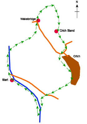
From the railway station take the first metal bridge across the railway track but not the second stone bridge, which crosses the canal. Instead, take the wooden steps, on the right, down onto the canal path.
Turn left, and walk along the canal path to the road, which you cross, to continue alongside the canal. There is some alternative free parking at this spot.
When you meet a black metal bridge cross it to enter the woods on the opposite side of the canal. Take the footpath on the left, to head uphill through the woods to a road.
Cross the road to follow the clear footpath, signed for Wakebridge, up through the woods past some cliffs on the right where you often find groups climbing and abseiling. Ignoring a squeeze stile on the left, continue straight ahead, to a wooden stile into a field where Crich Stand can be seen high above you.
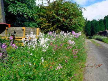
Follow the clear path across the field to a stile into another wooded area and a second stile into another field where wildflowers are allowed to grow in abundance. The footpath will take you around the right hand side of the field to a squeeze stile onto a road.
Turn right and then cross the road to take the track, on the left, signed for Plaistow Green. The track takes you into the campsite at Cliff Farm. As you approach the farmhouse the footpath is clearly visible on your right.
Crossing the small stile, next to the gate, follow the footpath uphill. Ignoring the stile on the left, which is signed for Plaistow Green, continue straight ahead uphill for Crich and Plaistow. As the track swings sharp right it is advisable to keep young children closely supervised as you are approaching the tramlines at Crich Tramway Museum.
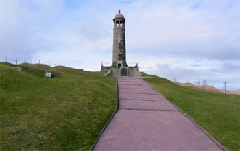
Cross the tramlines, checking for trams first, and then take the path on the left around the edge of the quarry, where Crich Stand dominates the view.
Keeping the fence on your right, follow the path around the edge of the quarry until you reach a squeeze stile into the back of Crich Stand. As this is a place of remembrance please note that picnics are not allowed in the grounds of Crich Stand.
The views from Crich Stand extend for miles in all directions and there are plenty of seats where you can sit and take them in. One of the seats is near the new memorial that contains the names of the members of the Mercian Regiment who lost their lives in Afghanistan in 2007.
Take the tarmac track past the tearoom to the entrance to Crich Stand. At the road turn right, to a T-junction. Continue straight ahead, past the entrance to Crich Tramway Museum, to Carr Lane, on the left-hand-side of the road.
Turn into Carr Lane but then almost immediately take the track on the left. It looks as if it is an entrance to a house but you will soon emerge via two squeeze stiles into a field. Head straight across two fields to the top of Castlehill. Heading downhill, continue straight ahead through Crich, until Bulling Lane appears on your right.
Turn into Bulling Lane and follow it around to the right until you reach the end of the road, where there is a footpath on the left signed for Sandy Lane � mile. Do not take the earlier footpath off Bulling Lane that is also signed for Sandy Lane but for a distance of � mile.
Follow the footpath downhill, across three fields, to cross a stile onto a track to the road.
Turn right along the road and then take the squeeze stile, which soon appears on the left, in front of the entrance to Chase Cliffe. The footpath turns left to follow the wall steeply downhill. For most of this steep section there is a handrail to hold onto.
When the footpath reaches the tarmac track, turn left and follow it downhill to its end. Continue straight ahead along the grass track that replaces it. Where the footpath splits bear right to cross the bridge over the canal.
Turn right and follow the path alongside the canal back to the station. |